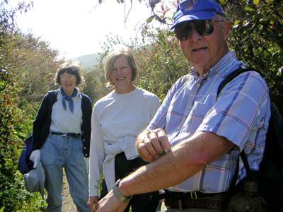
4-10-04 (L-R) Docent Anita Zehnder, visitor Ann, and Bob Traver, apply ancient Chumash remedy (Mugwort plant) to poison oak exposure on Bob's arm while hiking Coon Creek
This page contains information about
Adventures
with Nature non-interpreted exercise-based walks (called "Fast Hikes")
lead by Docents
Anita Zehnder (805) 528-4227 [no e-mail] and Mike
Baird mike [at} mikebaird d o t com
A topo map marked with all the trails followed is shown at
http://docents.info/images/topo-map-of-MDO-w-trails/
Here is a new AWN walk approved 5/16/07, entitled "Fast
Hike along the Morro Dunes Sandspit" to be lead by Docents Anita Zehnder and
Mike Baird. (11-5-07 Delete "Fast")
Hike along the Morro Dunes Sandspit: Great exercise,
companionship, and spectacular ocean, beach, and dune views. On this vigorous
non-interpreted hike, you will experience an infrequently visited area - the
entire four-mile length of the ocean side of the Morro Dunes Sandspit
- while viewing shore birds and learning about responsible beach combing. The
Morro Dunes sandspit forms the northern extension of Montaña de Oro State Park,
and is an ecologically diverse area that creates a unique barrier of sand dunes
separating Morro Bay from the Pacific Ocean. Bring water and snack. Wear
sturdy shoes. Meet at the Montaña de Oro Sand Spit parking area, located at the
end of Sand Spit Road, off Pecho Valley Road, approximately one mile inside the
entrance to Montaña de Oro State Park. Walks are scheduled to coincide
with an outgoing tide to make walking easier. 9 mi., 4.5 hrs.
Category: (H) "Hike -- Active to strenuous, no interpretation." (Strenuous)
shorter version for calendar:
Hike along the Morro Dunes Sandspit: Great exercise, companionship,
and spectacular ocean, beach, and dune views. On this vigorous hike, experience
the entire four-mile length of the ocean side of the sandspit - while
discussing ecological diversity and viewing many shore birds. Bring water and
snack. Wear sturdy shoes. Meet at the Montaña de Oro Sand Spit parking area, at
the end of Sand Spit Rd, off Pecho Valley Rd, one mile inside the park. Walk
coincides with an outgoing tide to make walking easier. 9 mi., 4.5 hrs.
Category: (H)
The following is an older related hike description used by mistake for the 9/07 calendar (and which was 3 miles originally), but Anita liked this description so much and wanted to de-emphasize the "fast" aspect - that it was decided on 9/5/07 to use this description going forward.
Sand Spit Walk - Examine dune plants. Enjoy the beauty of the surf and look at whatever has washed in. Watch birds feed and consider their adaptations for contact with a cold salty environment. Bring lunch, water and binoculars. Meet in Montaña de Oro State Park in the Sand Spit Parking Lot. Turn right on paved road 0.8 miles from park entrance. (A) 9 mi., 4.5 hours.
Summary: (as modified 7-17-06) (11-5-07 Delete "Fast")
Outline/Plan -- longer description (rev.
7-17-06) Docents: Anita Zehnder, Mike Baird
Theme: We gain inspiration and fully
appreciate nature by pooling insights with like-minded companions on active
hikes.
Hike along a well-defined but at times steep single-track path, gaining about 1300 feet of elevation. In these coastal scrub and chaparral environments, you will discover many native shrubs and beautiful seasonal wild flowers. Optionally bring binoculars to better view birds and the magnificent distance views of the mountains, sea, and bay. By briskly hiking with other outdoor-loving companions, you will find that your knowledge and curiosity will mix with that of the others, and the expert training of qualified State Park docents, to provide an enriched unique experience, satisfying to both your body and your soul. You may well meet others on this hike that you will run across again and again on other docent-led walks, making the outdoor experience even more enjoyable and valued. When you are hiking and see something interesting in nature, you can appreciate it more if you can share and discuss your experience with others. Some guests may take photos and share them with others after these walks using Internet web sites and e-mail. A topo map marked with our trail is shown at http://docents.info/images/topo-map-of-MDO-w-trails/
The docents will be prepared to discuss natural history topics as they come up, or may choose to give one or more short talks depending on the guests’ interests. However, the hike will generally proceed with only a few very brief rest or interpretation stops to make sure we maintain an aerobic and healthy experience. At the top of Valencia Peak we will rest for a snack for about 10-15 minutes, before returning on the same path to our starting point. The hike will be paced to meet the needs and abilities of the participants. This hike is conducted by two docents... one leading, and one following. In this way, if any hikers need to proceed at a slower pace, or need to return without completing the loop, the follow-docent is available to assist those guests. We invite suggestions for improving our hikes and walks, and we encourage your feedback and evaluation during and after the event. Our objective is to make sure that you thoroughly enjoy and benefit from the natural beauty of our State Parks, and learn the importance of, and your role in, preserving these precious resources.
Related Resources:
A photo essay of Valencia Peak is online at
http://morro-bay.com/outdoor/valencia/6-16-01hike.htm
Docent
George Mason's 12-page Booklet: Self-Guided Geology Walk to Valencia Peak
(Montaña de Oro State Park, CA)
Summary: (as modified 7-17-06) (11-5-07 Delete "Fast")
Outline/Plan -- longer description (rev.
7-17-06) Docents: Anita Zehnder, Mike Baird
Theme: We gain inspiration and fully
appreciate nature by pooling insights with like-minded companions on active
hikes.
Hike along a well-defined but at times steep single-track path, crossing over several 1000 foot peaks on the Ridge and Barranca loop trials. In these coastal scrub and chaparral environments, you will discover many native shrubs, trees, and beautiful seasonal wild flowers. Optionally bring binoculars to better view birds and the magnificent distance views of the mountains, sea, and bay. By briskly hiking with other outdoor-loving companions, you will find that your knowledge and curiosity will mix with that of the others, and the expert training of qualified State Park docents, to provide an enriched unique experience, satisfying to both your body and your soul. You may well meet others on this hike that you will run across again and again on other docent-led walks, making the outdoor experience even more enjoyable and valued. When you are hiking and see something interesting in nature, you can appreciate it more if you can share and discuss your experience with others. Some guests may take photos and share them with others after these walks using Internet web sites and e-mail. A topo map marked with our trail is shown at http://docents.info/images/topo-map-of-MDO-w-trails/
The docents will be prepared to discuss natural history topics as they come up, or may choose to give one or more short talks depending on the guests’ interests. However, the hike will generally proceed with only a few brief rest or interpretation stops to make sure we maintain an aerobic and healthy experience. At the one-third way point on top of Hazard Peak, and/or at the two-thirds-way point, as we transition from the Ridge Trail to the Barranca Loop Trail, we will rest for a snack for about 15 minutes, before continuing on to the Islay Creek Road leading back to our starting point. The hike will be paced to meet the needs and abilities of the participants. This hike is conducted by two docents... one leading, and one following. In this way, if any hikers need to proceed at a slower pace, or need to return without completing the loop, the follow-docent is available to assist those guests. We invite suggestions for improving our hikes and walks, and we encourage your feedback and evaluation during and after the event. Our objective is to make sure that you thoroughly enjoy and benefit from the natural beauty of our State Parks, and learn the importance of, and your role in, preserving these precious resources.
Summary: (as modified 7-17-06) (11-5-07 Delete "Fast")
Outline/Plan -- longer description
(rev. 7-17-06) Docents: Anita Zehnder, Mike Baird
Theme: We gain inspiration and fully
appreciate nature by pooling insights with like-minded companions on active
hikes.
Hike a well-defined wide fairly level path, crossing over six small shaded bridges along Coon Creek. In this riparian landscape you will discover many berries, shrubs, trees, and beautiful seasonal wild flowers. Optionally bring binoculars to better view the many birds. By briskly hiking with other outdoor-loving companions, you will find that your knowledge and curiosity will mix with that of the others, and the expert training of qualified State Park docents, to provide an enriched unique experience, satisfying to both your body and your soul. You may well meet others on this hike that you will run across again and again on other docent-led walks, making the outdoor experience even more enjoyable and valued. When you are hiking and see something interesting in nature, you can appreciate it more if you can share and discuss your experience with others. Some guests may take photos and share them with others after these walks using Internet web sites and e-mail. A topo map marked with our trail is shown at http://docents.info/images/topo-map-of-MDO-w-trails/
The docents will be prepared to discuss natural history topics as they come up, or may choose to give one or more short talks depending on the guests’ interests. However, the hike will generally proceed with only a few brief rest or interpretation stops to make sure we maintain an aerobic and healthy experience. At the half-way point, at the end of the Coon Creek path, we will rest for a snack for about 15 minutes, before returning. The hike will be paced to meet the needs and abilities of the participants. This hike is conducted by two docents... one leading, and one following. In this way, if any hikers need to proceed at a slower pace, or need to return early, the follow-docent is available to assist those guests. We invite suggestions for improving our hikes and walks, and we encourage your feedback and evaluation during and after the event. Our objective is to make sure that you thoroughly enjoy and benefit from the natural beauty of our State Parks, and learn the importance of, and your role in, preserving these precious resources.
4-10-04 (L-R) Docent Anita Zehnder, visitor Ann, and Bob Traver, apply
ancient Chumash remedy (Mugwort plant) to
poison oak exposure
on Bob's arm while hiking Coon Creek
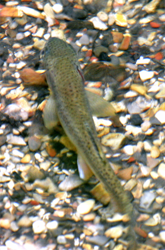

8-5-06 a Steelhead Trout, and a Vole seen along Coon
Creek at
Montaña de Oro
Here are trail mileage and elevations for rescue information, proveded by Paul Oconer 6/6/09:
Coon Creek Trail mileage & elevations for Docents:
Start (at picnic benches) 0 138’
Creek Bottom .26 54’
1 st Bridge .45 75’
2 nd Bridge .75 105’
Lions Den 1.00 130’
Rattlesnake Flats Trail 1.26 211’
Creek Bed Crossing 1.41 188’
Table Rock 1.45 190’
Mother Oak 1.51 198’
3 rd Bridge 1.54 195’
4 th Bridge 1.68 212’
5 th Bridge 1.82 226’
6 th Bridge 1.97 240’
Oats Peak Trail 2.32 305’
Trail Terminus 2.53 352’
Total Mileage 5.1
Total Elevation Gain 298’
Blank self evaluation form mlb-2-25-06 (word,
.pdf)
obsolete hike desc. versions for ref.
This page is
http://morro-bay.com/docents/anitaz/ revised
02/18/2008 12:48 PM -0500
Go to
morro-bay.com
Docent Pages or
morro-bay.com home