Did Pedro de Unamuno Really Land in Morro Bay
in 1587? I Think Not!
For submission
to Nature Notes -- Mike Baird
Few of us question the validity of reported key events in Morro Bay's
history:
- 1542 Juan
Rodriguez Cabrillo entered Estero Bay and named Morro Rock (but
he did not land).
- 1587 Pedro de Unamuno entered Morro Bay
(naming it "Puerto de San Lucas") and sent
an expedition to the vicinity of present day San Luis Obispo, taking possession in the name of Spain's King Philip.
- 1603 Sebastian
Vizcaino sailed into Estero Bay and christened the Santa Lucia Coast range.
- 1769 Spain sent expeditions to Alta California by land and by sea, to establish presidios, settlements,
and missions.
- 1769
Portola's
well-documented overland party camps near Morro Bay.
Adapted from
Lynne
Landwehr.
So, in 1587, 45 years after Juan Cabrillo sighted
Morro Rock (but did not enter Morro Bay due to the treacherous environment), this Pedro
Unamuno fellow is reported to have simply landed on a beach here and gone
about his business of "fending off native Indian attacks from a nearby
hillside." There seems to be
little public doubt about this -- and there is even a plaque
posted at Coleman Park in Morro Bay, commemorating this landing.
The thesis of this article is that Unamuno's
reported landing did not occur in Morro Bay. The
"Puerto de San Lucas" that Unamuno discovered would not appear in nautical
charts -- and it almost surely was not present day Morro Bay. However, it
well could
have been near near Avila 15 miles to the south.
The remainder of this article is based largely on an
account by historian Hector Santos (Ref.) -- published at
http://www.bibingka.com/sst/esperanza/morrobay.htm
The popular conclusion that Pedro de Unamuno landed in
Morro Bay is based almost entirely on 1929 conclusions by one Henry R. Wagner
(Ref.). Wagner presumably knew about the topography of Morro
Bay, Morro Rock, the sand spit as it existed in 1929, and the harbor's difficult
entrance at the time... but chose to ignore the lack of any mention of these
features by Unamuno. Instead, Wagner relied as his main evidence the computation of the latitude by the ship’s pilot, Alonso Gomez.
Unamuno said, “While thus anchored, about two harquebus-shots off the beach, we observed the sun between eleven and twelve o’clock noon, and found the port to be in full 35½º.” Morro Bay happens to be at latitude 35º 22', almost exactly what Unamuno
reported. We should note that the accuracy of mechanical astrolabes used
in the 16th century leaves a lot to be desired.
Here is a photo  of a typical primitive astrolabe
of the day. These are hardly devices
worthy of computing latitude to a fraction of a degree. Unamuno stated that they made their observation between 11:00 am and 12:00 noon. It was not a
more accurate night observation of the north star Polaris. It
was also not made exactly at noon and would have required the
interpolation of values in their charts, adding to errors already built
in.
of a typical primitive astrolabe
of the day. These are hardly devices
worthy of computing latitude to a fraction of a degree. Unamuno stated that they made their observation between 11:00 am and 12:00 noon. It was not a
more accurate night observation of the north star Polaris. It
was also not made exactly at noon and would have required the
interpolation of values in their charts, adding to errors already built
in.
Wagner actually suspected that Unamuno might have
landed in Avila's San Luis Bay 15 miles to the south, but dismissed that
possibility... preferring instead to reply solely on the latitude computation.
Unamuno probably made his way to the vicinity of present day San Luis Obispo.
And, there is some evidence that the Indians in San Luis Obispo Bay displayed an
acquaintance with Mexicans eight years later... supporting an argument that
Unamuno landed there instead.
Here is an expansion of the arguments suggesting that the Unamuno
landing never occurred at present day Morro Bay:
Firstly, no mention was ever made of the existence of Morro Rock.
Obviously, Morro Rock existed in 1587, and it would have been hard to miss
during a two-day stay. How could anyone have made such an historic
landing, lasting several days, and not have mentioned Morro Rock? Trying
to rationalize their account... did they perhaps land on the beach
north of the Rock in Estero Bay (where there are no hillsides near
the coast ,as chronicled); or, did they enter the nascent Morro Bay harbor,
where there was no "beach" per se (only mudflats,
salt marsh, and an outer sand spit), navigating the then shallow channels
and treacherous currents (and not mention such a configuration?).
Secondly, Unamuno made no mention of the presence of a
sand spit. Wagner, who translated and interpreted Unamuno's handwritten journal,
personally believed that the sand spit did not exist in 1587 and that the bay was wide open at the time.
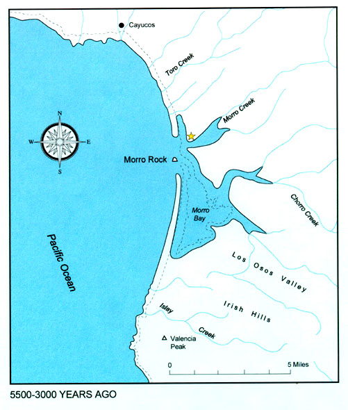
We know today that the sand spit existed in 1587. Archeological
data chronicle native sites on its northern end of the sand spit, dating to 4000 years ago."
Here is a map of the Morro Bay area as envisioned 3000
- 5500 years ago
,
and the sand spit is shown to exist even back then.
(from http://www.farwestern.com/morrobay/morro.htm
). Portola recognized the sand spit in his reports from 1769 (although
there is some controversy as to whether or not the south end of the bay --
Shark Inlet -- might not have been open to the sea at that time).
It appears that Wagner simply chose to "reason away"
vast conflicting topological evidence in favor of one inaccurate latitude
measurement.
Here is a topographical map of Morro Bay from 1897
 (view
smaller 638x814 map; print
larger 2550x3255 map). where the sand spit continues to assume its basic
form enclosing the bay.
(view
smaller 638x814 map; print
larger 2550x3255 map). where the sand spit continues to assume its basic
form enclosing the bay.
There are many photos of the Morro Bay harbor from around
1900 (well before the Rock was connected to the mainland, and the channel dredged)
(e.g., see http://morro-bay.com/photos-maps/
). The description of a simple "beach" landing (with no mention
from Unamuno of the Morro Rock, the harbor mudflats, the harbor salt marsh,
the harbor entry surf and currents, the all-encompassing sand spit...) does not seem at all
consistent with what we know about Morro Bay harbor from 100 years ago.
A third weaker argument is that It was stated that the Unamuno party camped for the night under
great oak trees near a river. This is possible, but not highly likely
near Morro Bay. Of the several small creeks
entering, or near, Morro Bay (Morro Creek, Chorro Creek, and Los Osos Creek
furthest to the south), the first two of these creeks do not harbor great oak trees today.
We know that the general area of Morro Bay was almost treeless before Franklin
Riley promoted them in the new settlement in 1864. The Avila Beach, Port San Luis
area 15 miles to the south, however, possibly harbors a more sizeable river with
correspondingly larger surrounding
giant oak trees.
So, why do we think that Pedro de Unamuno landed in
Morro Bay in 1587?
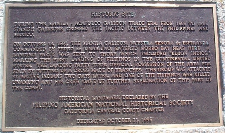
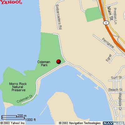
Pedro Unamuno's claim is reflected in the text
of a plaque, which is located off Coleman Drive, near the
corner of Embarcadero Road, in Coleman Park next to the playground. Here
is a map to its location. Here is a
photo of the plaque, and a transcription of what it says:
Historic Site
During the Manila-Acapulco Galleon Trade era from 1565 to 1815 Spanish galleons crossed the pacific between the Philippines and Mexico. On October 18, 1587, the Manila Galleon Nuestra Senora de Esperanza commanded by Pedro de Unamuno entered Morro Bay near here. A landing party was sent to shore which included Luzon Indios, marking the first landing of Filipinos in the continental United States. The landing party took official possession of the area for Spain by putting up a cross made of branches. The group was attacked by native Indians two days later, and one of the Filipinos was killed. Unamuno and his crew gave up further exploration of this part of the coast.
Historical Landmark Declared by the
Filipino American National Historical Society
California Central Coast Chapter
Dedicated October 21, 1995
Unamuno's 1587 landing is briefly chronicled by the Filipino American National Historical Society
(Ref.), and the Amerasia Journal
(Ref.) reports the landing in substantial detail:
Here is a 1900
Map of California, (showing that the town of Morro Bay was called
simply "Morro,") and illustrating where a more likely landing
site could have been, such as in Port Harford (now called Port
San Luis near Avila Beach) about 15 miles to the south.
The Filipino community (see Americans of Filipino Descent
http://personal.anderson.ucla.edu/eloisa.borah/filfaqs.htm#history
and
http://personal.anderson.ucla.edu/eloisa.borah/chronology.pdf
) is rightfully proud to want to document Unamuno's reported landing, in which
Luzones Indios appear to have been the first explorers to have landed in Central
California in 1587. Whether or not that landing was in Morro Bay is open
to interpretation. Let's indeed celebrate the landing -- but let's also do
our best to pinpoint its most likely location (which most likely was not Morro
Bay).
The truth may never be known.
More historical information about Morro Bay can be found at http://morro-bay.com/historical/
References:
- Lynne Landwehr. Lynne's web site "History
in San Luis Obispo County"
http://HistoryinSLOCounty.org
has a timeline
http://HistoryinSLOCounty.org/Timeline%20for%20Morro%20Bay.htm
which in turn was derived from Dorothy Gates and Jane Bailey's Morro Bay's
Yesterdays, Morro Bay: El Morro Publications, 1982, Third printing 2001 by Central Coast
Press... based on newspaper headlines assembled by Mrs. Shirley McGuire during Morro Bay Centennial, 1970.
- Hector Santos. Hector Santos's
Sulat sa Tansô
online newsletter (devoted to ancient Philippines history) ( see http://www.bibingka.com/sst/esperanza/morrobay.htm
and http://www.bibingka.com/sst/esperanza/indios.htm
) details
the landing story and makes the argument, in fuller detail, that Unamuno did not land in Morro Bay --
it is essential reading for anyone interested further in this topic.
- Filipino American National Historical Society
web site: Unamuno's 1587 landing is chronicled
http://www.fanhs17.com/oldfiles/timeline.html
at the , http://www.fanhs17.com/
- Amerasia Journal 21.3,
Volume 21, 1995, also reports this event (see http://www.sscnet.ucla.edu/esp/aasc/aj_index.html
http://www.sscnet.ucla.edu/esp/aasc/aj/aj21_3.html
)
-
Licuanan, Virginia Benitez and José Llavado Mira. The Philippines under Spain: A compilation and translation of original
documents, Book IV (1583-1590). Manila, 1993.
-
Mathes, W. Michael. The capture of the Santa Ana, Cabo San Lucas, November, 1587. Los Angeles, 1969.
-
Wagner, Henry R. Spanish voyages to the northwest coast of America in the sixteenth
century. San Francisco, 1929.
-
Santos, Hector. "The first Philippine Indios in California" in Sulat sa Tansô at
http://www.bibingka.com/sst/esperanza/indios.htm
. US, April 3, 1997.
This page is published at http://morro-bay.com/docents/mike-baird/nature-notes/unamuno-1587/
and contains hyperlinks to more information. Here are some of the embedded
hyperlinks.
morro-bay.com Revised
Monday, February 18, 2008 01:24:24 PM
 of a typical primitive astrolabe
of the day. These are hardly devices
worthy of computing latitude to a fraction of a degree. Unamuno stated that they made their observation between 11:00 am and 12:00 noon. It was not a
more accurate night observation of the north star Polaris. It
was also not made exactly at noon and would have required the
interpolation of values in their charts, adding to errors already built
in.
of a typical primitive astrolabe
of the day. These are hardly devices
worthy of computing latitude to a fraction of a degree. Unamuno stated that they made their observation between 11:00 am and 12:00 noon. It was not a
more accurate night observation of the north star Polaris. It
was also not made exactly at noon and would have required the
interpolation of values in their charts, adding to errors already built
in. 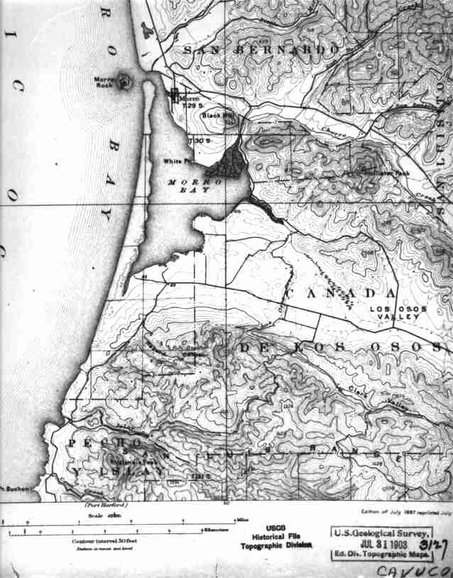