 Late 1880s. Schooner "Jessie" shown, captained by Mr.
Church. Photo taken from north shore by Arnold Schneider.
Late 1880s. Schooner "Jessie" shown, captained by Mr.
Church. Photo taken from north shore by Arnold Schneider.Below are some select photos and caption information, adapted by permission, from Morro Bay's Yesterdays, by Gates and Bailey.
Click to enlarge the following photos.
Late 1880s. Schooner "Jessie" shown, captained by Mr.
Church. Photo taken from north shore by Arnold Schneider.
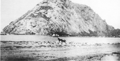
 About 1894. From the shore north of Morro Rock, looking south (believed to
be near where the causeway is today). Photo by Singleton.
About 1894. From the shore north of Morro Rock, looking south (believed to
be near where the causeway is today). Photo by Singleton.
![]() Early 1890s. Blasting of the east face of Morro Rock. Photo from
north shore taken by S. Shuman.
Early 1890s. Blasting of the east face of Morro Rock. Photo from
north shore taken by S. Shuman.
![]() 1910. Trestle with railroad tracks to quarry on Morro Rock, from shore.
Photo by S. Shuman.
1910. Trestle with railroad tracks to quarry on Morro Rock, from shore.
Photo by S. Shuman.
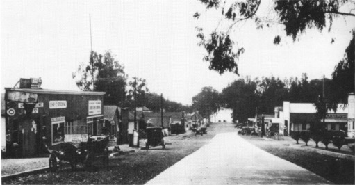
![]() Around 1911. Looking north on Main Street at Morro Bay Boulevard.
Eucalyptus trees were planted by Franklin Riley. Photo by Arnold
Schneider.
Around 1911. Looking north on Main Street at Morro Bay Boulevard.
Eucalyptus trees were planted by Franklin Riley. Photo by Arnold
Schneider.
![]() 1915. 5th Street, now called Morro Bay Boulevard, looking toward the
bay. Photo by S. Shuman.
1915. 5th Street, now called Morro Bay Boulevard, looking toward the
bay. Photo by S. Shuman.
 Taken in the 1920s. 5th Street, now called Morro Bay Boulevard, looking
west toward the bay. Photo by Noma Stocking.
Taken in the 1920s. 5th Street, now called Morro Bay Boulevard, looking
west toward the bay. Photo by Noma Stocking.
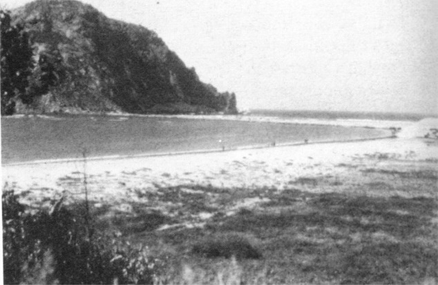 Late 1920s. You can see the surf pouring into the north entrance to the
harbor. This must have been close to Portola's
landing spot in 1769. Photo by N. Moses.
Late 1920s. You can see the surf pouring into the north entrance to the
harbor. This must have been close to Portola's
landing spot in 1769. Photo by N. Moses.

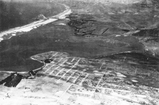
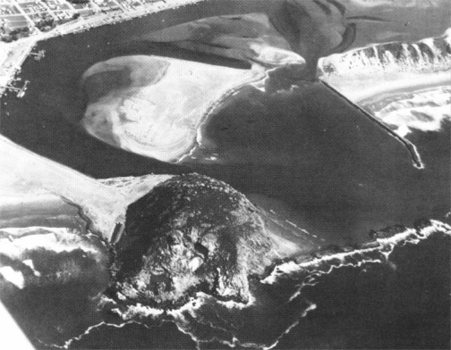
 Pre 1933. Morro Rock is still an island. The tide appears to be
relatively high, as the estuary is mostly covered by water. The current
day communities of Los Osos and Baywood Park are barely populated.
Rightmost photo by E. Roy.
Pre 1933. Morro Rock is still an island. The tide appears to be
relatively high, as the estuary is mostly covered by water. The current
day communities of Los Osos and Baywood Park are barely populated.
Rightmost photo by E. Roy.
 1933. The causeway to Morro Rock is started. Here is shown a
skeleton laid out. This is a view to the east from Morro Rock. Photo by S.
Shuman.
1933. The causeway to Morro Rock is started. Here is shown a
skeleton laid out. This is a view to the east from Morro Rock. Photo by S.
Shuman.
 May, 1953. This photo was taken just as the PG&E (now
Duke
Energy (news))
plant started construction. Photo taken from the top of Morro Rock by Glen
Bickford.
May, 1953. This photo was taken just as the PG&E (now
Duke
Energy (news))
plant started construction. Photo taken from the top of Morro Rock by Glen
Bickford.
 April, 1955. You can see the damage done to the breakwater due to high
seas. Photo by Glen Bickford.
April, 1955. You can see the damage done to the breakwater due to high
seas. Photo by Glen Bickford.