
Hector Santos, Editor and Publisher
http://www.bibingka.com/sst/esperanza/morrobay.htm
for reference obly... this will be deleted.
Did Philippine indios really land in Morro Bay?
by Hector Santos
© 1995, 1997 by Hector Santos
All rights reserved.
On October 21, 1995 the Filipino American National Historical Society (FANHS) proudly unveiled a plaque commemorating the landing of the first Filipinos in California. The celebration had been planned for a long time and dignitaries were invited to witness this memorable and exciting moment. Proud Filipinos came from all over the United States to be there for this occasion.The Morro Bay Celebration Edition of the FANHS newsletter Generations (Fall 1995) said in part:
After a year of planning and fund raising activities, California Central Coast Chapter will dedicate a national historical marker to commemorate the landing of the Spanish galleon Nuestra Señora de Esperanza in Morro Bay on Oct. 18, 1587. This marked the first presence of Filipinos (referred to in the ship’s logs as Luzones Indios) in the continental United States.California Governor Pete Wilson sent a letter of congratulation to FANHS saying:
It is my sincere pleasure to join Filipino Americans from all across the nation in celebrating the dedication of the Morro Bay monument, commemorating the first documented Filipino presence in the Continental United States.Nearly 400 years ago, a Spanish galleon sought reprieve from the treacherous waters off Morro Bay. Among its occupants were several Filipinos who were among the first non-Europeans to gaze upon California.
The distinctive dome of the Morro Rock that is sometimes called the "Gibraltar of the Pacific." Pedro de Unamuno does not mention it in his account. The dome is so striking when viewed from anywhere that it is improbable that anyone writing about Morro Bay will forget to describe it.
Here is a description from the California Coastal Commission's California Coastal Access Guide (1983):
Morro Rock and the six other volcanic peaks between Morro Bay and the City of San Luis Obispo were formed by volcanic activity over 20 million years ago. The Rock marks the narrow and once treacherous entrance to Morro Bay, sighted originally by the Spanish explorer Juan Cabrillo in 1542. Cabrillo never landed there, and it wasn't until Juan Gaspar dr Portola's expedition in 1769 that Europeans first explored the land and met the Chumash Indians, the native inhabitants of the region. Chumash villages and camps have been found at Los Osos Creek, and Montana de Oro and Morro Bay State Parks.
Today’s Filipino Americans are starved for historical recognition and will jump at any opportunity to find anything they can claim as historic. This is not an unusual stance for minorities as some Jews have likewise claimed that Jewish help in the employ of Columbus were really the driving force behind his expedition to the New World. They claim that early Jews had planned the expedition to escape discrimination in Spain in the late 15th century.
Some African Americans have similar revisionist claims, one being that the ancient Egyptian kingdoms were ruled by their ancestors and that they were somehow involved in the development of western civilization.
Filipinos have taken this claim-to-fame penchant a step farther into triviality when some of them convinced a historical group in Illinois to install a plaque in a Chicago railway station because José Rizal passed through as he crossed the United States on his way to Europe. Presumably, Rizal stepped down to use the restroom and that occasion needed to be preserved for posterity. Another persistent Filipino group managed to have a plaque installed at a New York City hotel because Rizal stayed there for a few days.
Never mind that nothing of consequence happened at either of these locations—it was enough that Rizal passed by. These plaques remind me of “George Washington Slept Here” signs in some New England inns and the “Kilroy was here” signs from World War II. If these remembered events are not historical trivia, then these plaque mongers must surely be guilty of trivializing history.
We can argue that the Morro Bay plaque is not on the same superficial level as the Rizal plaques. The Morro Bay landing is historic in the sense that it gives Filipinos a record of their participation in the affairs of the New World, albeit unwillingly and under involuntary servitude.
But did the indios from the Nuestra Señora de Buena Esperanza actually land in Morro Bay?
The source of information FANHS uses to make this claim is Henry R. Wagner’s Spanish Voyages to the Northwest Coast of America in the Sixteenth Century (California Historical Society, San Francisco, 1929) which included an English translation of Unamuno’s account of his travels.
Wagner’s main evidence for the Morro Bay location is the computation of the latitude by the ship’s pilot, Alonso Gomez. Unamuno said, “While thus anchored, about two harquebus-shots off the beach, we observed the sun between eleven and twelve o’clock noon, and found the port to be in full 35½º.” Morro Bay happens to be at latitude 35º 22', almost exactly what Unamuno reported.
However, the accuracy of astrolabes used in the 16th century leaves a lot to be desired. I have a working replica of such a device from that era. There are no bubbles or mirrors to aid in obtaining the sun’s altitude. It relies on gravity to establish the horizon so that its use on the pitching deck of a ship requires both a steady hand and an oscillation frequency that did not interact with the instrument’s mass to cause it to swing.
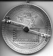
Two sides of an astrolabe similar to those used by galleon pilots in the 16th century. The instrument was suspended from a ring to make it hang vertically, thus setting the horizon. Sighting of a heavenly body was done by using the rotatable arms. One side (left) was used for sighting the sun and had holes for sunlight to pass through. The other side was used for sighting stars.
Notice that Unamuno stated that they made their observation between 11:00 am and 12:00 noon. It was not a night observation of Polaris, the north star, that would have been more accurate. It was also not made exactly at noon and would have required the interpolation of values in their charts, adding to errors already built in.
Wagner tries to explain away some of the discrepancies in topological features described by Unamuno in his narrative. He also acknowledges that Unamuno’s failure to describe Morro Rock, a very distinctive feature of the bay that one can hardly miss, speaks strongly against Unamuno’s landing in Morro Bay and that it is possible that Unamuno went ashore from San Luis Obispo Bay. (Missing the Morro Rock in Morro Bay is like sailing into Legaspi City in Albay and not noticing the Mayon Volcano.) But he thinks that Unamuno “simply forgot to speak of the Morro.” This is what he says:
His failure to mention Morro Rock, certainly a very conspicuous object in the landscape at Morro Bay, or in fact anywhere between Pt. Buchon and Pt. Cayucas might well be urged as negating the theory that he had been in Morro Bay, and the fact that the Indians in San Luis Obispo Bay when Cermeño was there some eight years later displayed an acquaintance with Mexicans would give some weight to the theory that Unamuno had been there. The topography, however, of the shore of this bay and that of the country just inside does not correspond sufficiently closely to Unamuno’s description to make this at all likely. Very probably, he simply forgot to speak of the Morro. Whether he went inland from Morro Bay or San Luis Obispo Bay, however, he must have reached the vicinity of the City of San Luis Obispo.Wagner easily dismisses such discrepancies as the current narrow entrance to Morro Bay as the result of being filled in and the shifting of sand. How convenient that such things happened in Morro Bay but not in San Luis Obispo Bay and the other wide bays in nearby areas. I am more inclined to believe that Wagner was influenced very much by the latitude 35½º reported by Unamuno and that he tried to make everything else consistent with it.
An aerial shot of Morro Bay. The bay is in the foreground and its entrance is that narrow channel between the sand bar in the center of the photograph and Morro Rock. Note the breakwaters built to protect the channel entrance into the bay. Until the breakwaters were constructed, getting into the bay was very difficult.
The map on the right shows the sand spit that almost closes off Morro Bay. Morro Rock, on the north side of the channel, guards the entrance to the harbor. It is a dome-shaped rock surrounded by flat land.
Wagner, the authority cited by FAHNS, believes that the sand spit did not exist in 1587 (it was not described by Unamuno, either) and that the bay was wide open. He does not cite any geological study to support his belief.
Juan Cabrillo discovered the Rock in 1542 but did not land because of treacherous currents.
San Luis Obispo is at the lower right. To the north of Morro Bay are Monterey Bay and Santa Cruz Bay (not shown).
On the same subject as to where Unamuno landed, another scholar, W. Michael Mathes, thinks that the Esperanza landed in Santa Cruz, a point much farther north of Morro Bay. (Mathes 1969: 14)
(I wonder what would have happened if FANHS did not have a California Central Coast Chapter but had a Santa Cruz County Chapter instead. Would that chapter have quoted Mathes instead of Wagner so that they could have a plaque in their area?)
Morro Rock as seen from the sea. No matter where you view the distinctive dome of the Morro Rock, you will not forget it.
Morro Rock as seen across the channel entrance to the bay. This view is looking north from the sand spit.
This controversy as to where the real landing site was reminds us that establishing locations mentioned in ancient documents is not an easy task. Topography and ecological conditions change, placenames are certainly different, and reported latitudes, longitudes, and distances are subject to errors. We have seen examples of earlier controversies such as the first Columbus landing in America and the first mass in the Philippines.
The Unamuno document proves that Filipinos landed in Central California in 1587. Were they the first? Until other documents show otherwise, they certainly were. They were unwilling and unknowing pawns on this trip since they did not have a choice. They were let ashore twice in California before they moved on to Acapulco.
The Sacrament Bee of May 19, 1996 quotes Marge Talaugon, a spokeswoman for the Filipino American Historical national Society as saying, "This is where Filipino American history started."
A big claim. How did this event affect the history of America, Spain, Mexico, or the Philippines? How much did it change the course of the lives of indios in the Philippines?
Not much, I’m afraid. Any Filipino American claiming connections to the Luzones indios who were in California in 1587 is reaching too far and would be the laughing stock of those who know that the indios on the Esperanza were just passing through. They left no lasting legacy in California.
Unamuno was soon forgotten. Less than a decade after his landing, nothing more was heard about him. The Puerto de San Lucas that he “discovered” did not even appear in any nautical chart. We may never know where it really was.
Perhaps, this was a fitting end to the career of a man (see “The characters on the Esperanza”) who initially set out to make a quick buck for himself and had the temerity to disobey direct orders in order to pursue his personal goals of profit.
This article was rewritten for the World Wide Web and first appeared in the November 1995 issue (2: 8) of Sulat sa Tansô.
REFERENCESTo cite:
- California Coastal Commission. Coastal Access Guide. Berkeley, 1983.
- Cordova, Dorothy, ed. Generations (Fall 1995). Seattle, 1995.
- Licuanan, Virginia Benitez and José Llavado Mira. The Philippines under Spain: A compilation and translation of original documents, Book IV (1583-1590). Manila, 1993.
- Magagni, Stephen. " 'Model Minority' has faced racism, misrepresentation" in Sacramento Bee (May 19, 1996). Sacramento, 1966.
- Mathes, W. Michael. The capture of the Santa Ana, Cabo San Lucas, November, 1587. Los Angeles, 1969.
- Wagner, Henry R. Spanish voyages to the northwest coast of America in the sixteenth century. San Francisco, 1929.
Santos, Hector. "Did Philippine indios really land in Morro Bay?" in Sulat sa Tansô at http://www.bibingka.com/sst/esperanza/morrobay.htm. US, April 9, 1997.
Related Articles
Comments? Click here to send them.
Web design and hosting.