 (click to enlarge)
By
Curt Beebe 9-19-04
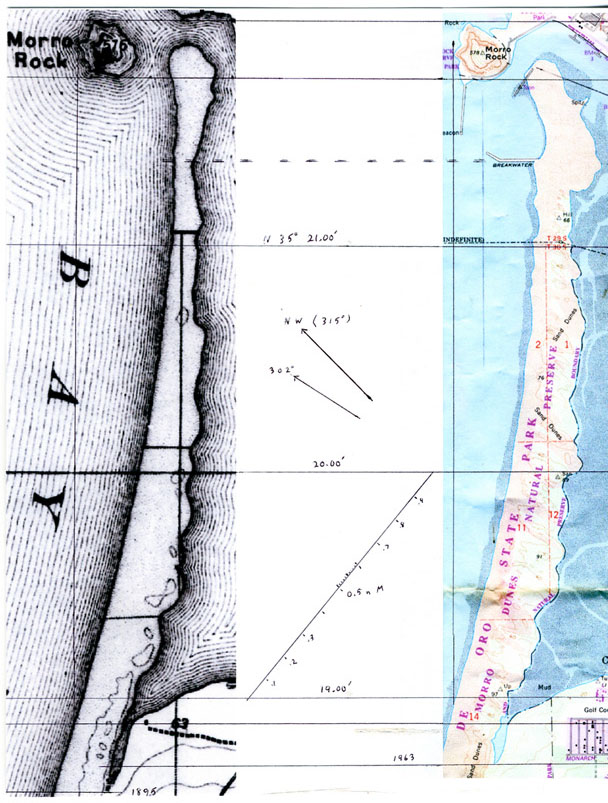
On the left is the 1897 USGS map, based on the 1895 survey; on the right is a
current topo, based on 1963 and 1987 data. The maps were shrunken and enlarged
until the distance from the north side of Morro Rock to the mouth of Shark Inlet
was the same, with the largest size, for detail, reproducible on 8 ½ x 11
stationery. At this size 77 millimeters equals 6076 feet, which equals one
nautical mile (nMile), which shows on the maps as a minute of latitude.
Notice that Shark Inlet is 0.1 nautical miles shorter than it used to be. Also
notice that the west side of the Sand Spit was farther east than it is now.
Our “northwest” wind produces blowouts on the Spit that are oriented from
approximately 302 degrees. However, for simplicity of comparison I chose to
measure the west-east dimensions of the Sand Spit every tenth of a nMile, from
18.8 to 21.2 minutes North latitude.
The difference in dimensions, from north to south in millimeters, is 6, 2, 6, 7,
7, 8, 3, 5, 4, 2, 3, 7, 6, 2, 2, 4, 4, 4, 4, 3, 2, 5, 2, and 3. The Spit is
getting thick faster to the north. The mean change is 6 for 21.2 to 20.0
minutes, and 3 for 19.9 to 18.8.
3 / 77 x 6076 = 237 feet, and 6 / 77 x 6076 = 474 feet in 68 to 92 years, equals
approximately 100 / 80 x 237 and 474 = 300 and 600 feet of change per century.
That compares reasonably closely with the rate of advance of the dunes measured
by Ernie Eddy and George Mason at the tip of Shark Inlet of 10 feet in 2 ½
years, 4 feet per year.
The difference in west-east position of the western edge of the Sand Spit is 5,
5, 5, 4, 5, 4, 3, 4, 4, 4, 3, 4, 2, 3, 3, 2, 3, 3, 4, 2, 2, 3, 2, 2, 1, and 0.
The means for this data are 4 and 2. Does this mean that 2/3 of the growth in
width of the Spit is westerly?
(click to enlarge)